The Trans-Iranian Railway is a 1,394 km line from Bandar Torkaman on the Caspian Sea to Bandar Imam Khomeini on the Persian Gulf, passing through Tehran. It was built between 1927 and 1938 under Reza Shah, paid for by domestic taxes rather than foreign loans, and crosses two mountain ranges by way of 224 tunnels and hundreds of bridges. UNESCO inscribed it as a World Heritage Site in 2021.
| Built | 1927–1938 (ceremonial start 1927; lines joined in August 1938) |
|---|---|
| Length | 1,394 km, standard gauge |
| Termini | Bandar Torkaman (formerly Bandar Shah), Caspian Sea; Bandar Imam Khomeini (formerly Bandar Shahpur), Persian Gulf |
| Engineering | 224 tunnels (11 of them spiral), 174 large and 186 smaller bridges (UNESCO) |
| Funding | State taxes, chiefly on sugar and tea |
| UNESCO | World Heritage Site no. 1585, inscribed July 2021 |
| Persian name | راهآهن سراسری ایران (Râh-âhan-e Sarâsari-ye Irân) |

Why a north–south line
When Reza Shah came to power Iran had almost no railways: a few kilometres of track near Tehran and a short Russian-built line from the border at Julfa to Tabriz. Goods moved by caravan and, increasingly, by truck on rough roads. A railway had been discussed since the Qajar era, but every plan had foundered on the rivalry of Britain and Russia, each of which feared a line that would serve the other.
Reza Shah’s government chose a route from the Caspian to the Persian Gulf through the capital. It avoided the Soviet and British-Indian borders and joined the two seas that bound the country. Critics at the time, and some historians since, argued that an east–west line, or a line to the Turkish or Iraqi border, would have carried more trade, and that the chosen route ran through some of the hardest terrain in Asia for reasons of prestige and strategy. Supporters replied that it opened the capital to both coasts and to the oil province of Khuzestan, and that it could be built without letting a foreign power choose the route.
Paid for at home
In 1925, while still prime minister, Reza Khan secured a law creating state monopolies on sugar and tea, whose revenues were reserved for the railway. Ordinary Iranians therefore paid for the line every time they sweetened a glass of tea. Avoiding foreign loans was a point of national pride: in the nineteenth century Iranian rulers had granted sweeping concessions to foreigners, such as the Reuter concession of 1872, and the government did not want the railway to become another lever of foreign control. UNESCO’s description of the line stresses the same point.
Building through the Alborz and the Zagros
Construction was formally launched in October 1927. In the first phase a German consortium worked on the northern section from the Caspian and an American firm, Ulen and Company, on the southern section from the Persian Gulf, with the easy lowland stretches built first. Progress on the mountain sections was slow and disputes multiplied, and in 1933 the government handed management of the remaining work to the Danish consortium Kampsax. Kampsax divided the line into lots and subcontracted them to firms from many countries; UNESCO counts 43 contractors in all. Engineers came from Germany, Denmark, Italy, Austria, Switzerland, Sweden, Czechoslovakia and elsewhere, and tens of thousands of Iranian labourers did the digging.
The northern climb
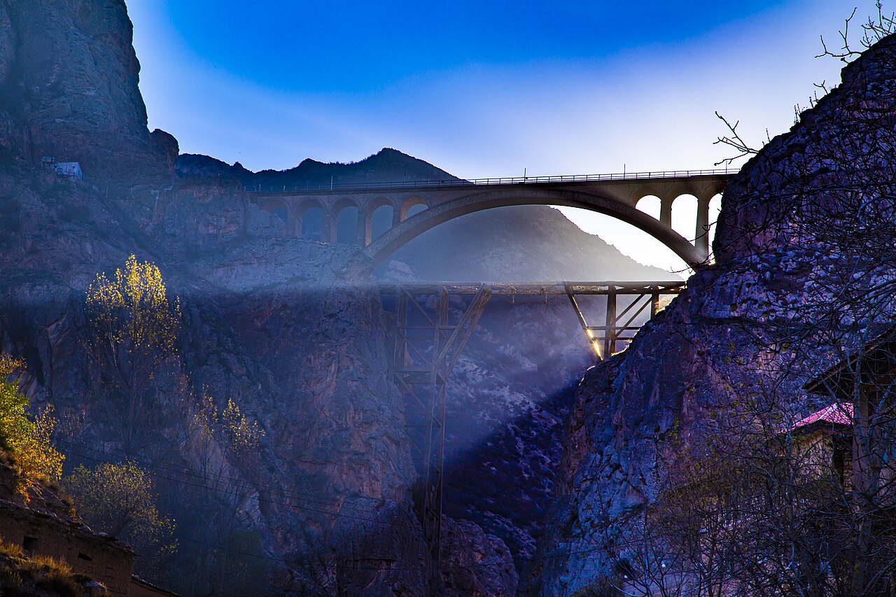
North of Tehran the line climbs from the Caspian lowlands of Mazandaran through the Talar valley and over the Alborz range near Firuzkuh, at a summit of more than 2,000 metres, before dropping to the plateau. In the Savadkuh district, where Reza Shah was born, it loops back on itself in spirals and switchbacks. The best known structure is the Veresk Bridge, completed in 1936: a stone arch spanning a gorge more than 100 metres deep. A popular story says its Austrian engineer stood beneath it with his family as the first train crossed, to prove his confidence; the story is often repeated but hard to document.
The southern descent
South of Qom and Arak the line threads the gorges of the Zagros along the Dez river valley in Lorestan, a stretch of tunnels and bridges that took years to complete, before reaching the plain of Khuzestan at Andimeshk and running on through Ahvaz to the Persian Gulf. The two halves of the line were joined in August 1938, ahead of the schedule set in the Kampsax contract.
- 1925 Law creates sugar and tea monopolies to fund the railway
- 1927 Construction formally begins
- 1928–1931 German and American syndicates build the lowland sections
- 1933 Kampsax takes over management of the remaining work
- 1936 Veresk Bridge completed
- 1938 Northern and southern lines joined; full route open
- 1941–1945 Allied forces run the line to supply the Soviet Union
- 2021 Inscribed on the UNESCO World Heritage List
From national symbol to wartime supply line
The railway was the showpiece of Reza Shah’s reign. Its completion was celebrated as proof that Iran could carry out a great modern project with its own money and on its own terms. Within three years, though, the strategic value of a line linking the Persian Gulf to the Caspian made Iran a target. After the Anglo-Soviet invasion of 1941, British and then American forces took over and expanded the railway to carry Lend-Lease supplies to the Soviet Union, the route known as the Persian Corridor. Many Iranians noted the irony that the railway built to protect Iran’s independence helped bring about its occupation.
How historians see it
Historians agree on the engineering achievement and differ on the economics. Ervand Abrahamian, among others, notes that the line was financed by regressive taxes on staples consumed by the poor, while its benefits went first to the state and the army. Stephanie Cronin and other writers on the period treat it as a central part of a state-building project that tied the provinces to Tehran. Writers sympathetic to Reza Shah see it as the clearest example of what his reign achieved. UNESCO’s citation focuses on the line as a work of engineering and on the international cooperation of its builders.
The railway today
The line is still in service and forms the spine of Iran’s rail network, now much extended. Passenger trains run between Tehran and the Caspian coast through the Savadkuh mountains, and the Veresk Bridge and the spiral sections of Savadkuh are popular with photographers and rail enthusiasts. The UNESCO listing covers the original 1,394 km route with its stations, bridges and tunnels. For trains and timetables, check current information from Iran’s national railway company before travelling. The northern section passes close to the landscapes described in our post on the north of Iran.
Persian words from this page
| راهآهن | râh-âhan | railway (literally “iron road”) |
| قطار | qatâr | train |
| پل ورسک | Pol-e Veresk | Veresk Bridge |
| تونل | tunel | tunnel |
| قند و شکر | qand o shekar | sugar (lump and granulated) |
| چای | châi | tea |
Sources and further reading
- UNESCO World Heritage Centre, Trans-Iranian Railway (inscribed 2021).
- Encyclopaedia Iranica, article “Railroads” (iranicaonline.org).
- Ervand Abrahamian, A History of Modern Iran (Cambridge University Press, 2008).
- Stephanie Cronin (ed.), The Making of Modern Iran: State and Society under Riza Shah, 1921–1941 (Routledge, 2003).
- Abbas Amanat, Iran: A Modern History (Yale University Press, 2017).
Want to learn Persian? Get the free Starter Pack
Get the 14-page printable Starter Pack (all 32 letters, a 7-day reading plan, 100 core words and 20 survival phrases) and a short 5-email course. Free.
More in The Pahlavi Era (1925–1979)
- Reza Shah Pahlavi
- Reza Shah’s Reforms
- The Trans-Iranian Railway
- Why Persia Became “Iran” in 1935
- The Unveiling Decree of 1936 (Kashf-e Hijab)
- The Anglo-Soviet Invasion of Iran (1941)
- The Persian Corridor and the Tehran Conference
- The Iran Crisis of 1946
- Mohammad Reza Shah’s Early Reign (1941–1953)
- The Tudeh Party
- Mohammad Mosaddegh
- The Nationalisation of Iranian Oil (1951)
- The 1953 Coup in Iran
- Fazlollah Zahedi
- The 1954 Oil Consortium Agreement
- SAVAK: The Shah’s Security Service
- The White Revolution (1963)
- The Uprising of June 1963 and Khomeini’s Exile
- The Hoveyda Years (1965–1977)
- The 2,500-Year Celebration of the Persian Empire (1971)
- The Oil Boom of the 1970s
- Intellectuals and Opposition in the 1960s–70s
- Iran as a Regional Power under the Shah
- Women in Pahlavi Iran
- The Cinema Rex Fire (1978)
- Black Friday (September 1978)
- The Shah Leaves Iran (January 1979)
- Farah Pahlavi
- The Pahlavi Family
- Forough Farrokhzad and Modern Persian Poetry
- Iranian Cinema before 1979