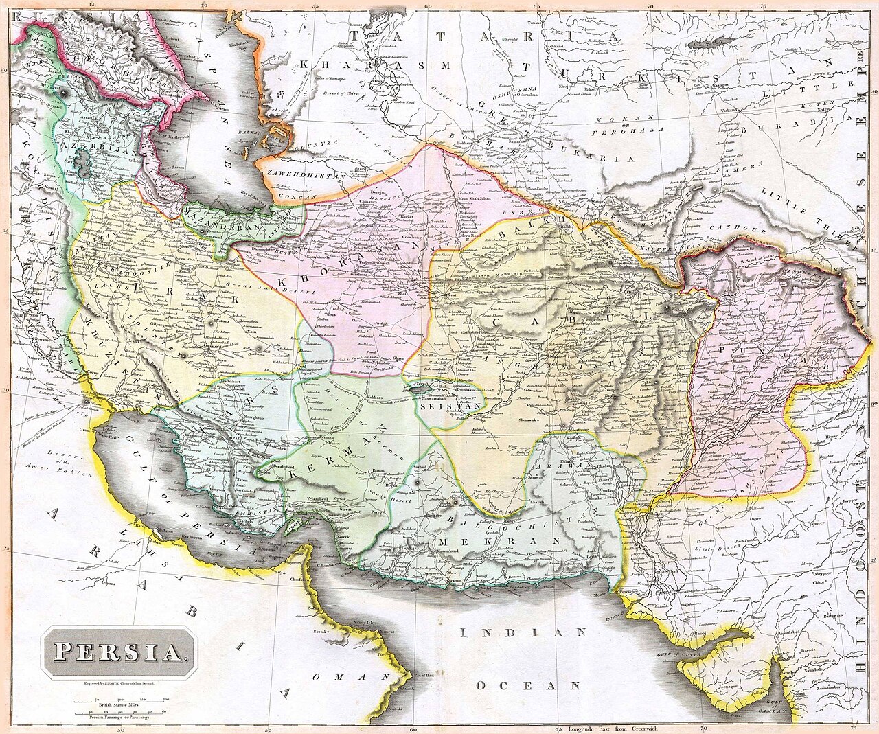
Iran’s borders have expanded and shrunk more than almost any other country’s. At its height under the Achaemenids the empire ran from the Aegean to the Indus; today’s Islamic Republic covers about 1.65 million square kilometres. Most of the present frontier was drawn between 1813 and 1914, when Qajar Iran lost the Caucasus to Russia and Herat to the Afghans, and Russian, British and Ottoman surveyors fixed lines that have changed little since.
| Area today | About 1,648,000 km² |
|---|---|
| Land neighbours | Iraq, Turkey, Armenia, Azerbaijan, Turkmenistan, Afghanistan, Pakistan |
| Seas | Caspian Sea, Persian Gulf, Gulf of Oman |
| Largest losses | Caucasus (1813, 1828), Herat and western Afghanistan (1857) |
| Old name for the homeland | Ērānšahr, “land of the Iranians” (Sasanian Middle Persian) |
Empires without fixed lines
Ancient empires had frontier zones rather than surveyed borders. The Achaemenid empire of the 5th century BCE, often estimated at around five million square kilometres, stretched from Egypt and Thrace to Central Asia and the Indus (see the satrapies). The Parthians held a smaller realm with the Euphrates as their usual frontier with Rome. The Sasanians gave the idea of a homeland its name, Ērānšahr, and guarded it with walls and forts such as the Gorgan Wall facing the steppe and the Derbent defences in the Caucasus; their western frontier ran through upper Mesopotamia and Armenia (see Persia and Rome).
For nine centuries after the Arab conquest, Iran was not a single state. Caliphs, then Iranian, Turkic and Mongol dynasties ruled shifting realms, some centred in Bukhara, Ghazni or Samarkand. Yet the idea of Iran survived, and the Ilkhanate revived “Iran” as the name of a political territory.
The Safavid core
The Safavids built the state whose outline is closest to modern Iran, plus the Caucasus, Herat and at times Kandahar and Baghdad. Its western border was fought over with the Ottomans and settled by the Treaty of Zuhab in 1639, which left Iraq in Ottoman hands (see Iran and the Ottoman Empire). Nader Shah briefly pushed far beyond it, to Delhi and Bukhara, but his conquests did not outlast him.

The Qajar losses
The 19th century gave Iran its present shape, mostly through loss.
- The Caucasus. The Treaty of Golestan (1813) and the Treaty of Turkmenchay (1828) gave Russia Georgia, Dagestan, the khanates of today’s Azerbaijan Republic and Armenia. The Aras river became the northern border.
- Afghanistan. After the Anglo-Persian War, the Treaty of Paris (1857) made Iran abandon its claim to Herat (see the loss of Herat). British arbitrators divided Sistan in 1872 and again, with the Helmand waters, in 1903 to 1905.
- Baluchistan. The line between Iranian and British-Indian Baluchistan was drawn by Frederic Goldsmid’s commission in 1871 to 1872 and later demarcated; Pakistan and Iran confirmed it by agreement in 1958.
- Central Asia. As Russia conquered the Turkmen lands, the Akhal Treaty of 1881 fixed the frontier along the Atrak river and the Kopet Dag, leaving Merv and the old Khorasan oases outside Iran.
- The Ottoman frontier. The Second Treaty of Erzurum (1847), the Constantinople Protocol (1913) and a demarcation commission (1914) fixed the line from Mount Ararat to the Persian Gulf, now Iran’s border with Turkey and Iraq. A 1932 exchange gave Turkey the slopes of Little Ararat in return for land further south.
Iranian schoolbooks and nationalist writers often present these treaties as a list of humiliations. Some historians point out that Qajar control of the Caucasus khanates and Herat had often been loose, so the treaties recorded as well as caused the loss; others stress the human cost for populations cut off from Iran.
The 20th century: water and islands
Later disputes were over rivers and the sea. The Shatt al-Arab (Arvand Rud) border with Iraq was set by the 1937 treaty along the Iranian bank; Iran rejected this in 1969, and the Algiers Agreement of 1975 moved the line to the deepest channel. Saddam Hussein tore up the agreement in 1980 at the start of the Iran-Iraq War, which ended in 1988 with the old border unchanged.
In the Persian Gulf, Iran long claimed Bahrain. After a UN mission reported in 1970 that Bahrainis wanted independence, the Iranian Majlis accepted the result. In November 1971, as Britain withdrew, Iran took Greater and Lesser Tunb and, under an agreement with Sharjah, Abu Musa; the United Arab Emirates still disputes these islands. The legal status of the Caspian was set out in a convention signed by the five coastal states in 2018, though the division of the seabed between Iran and its neighbours remains unsettled. Today’s 31 provinces are described in the provinces of Iran, and the land itself in the geography of Iran.
Iran beyond its borders
Historians often distinguish the Iranian state from a wider “Greater Iran” or Iranian cultural world, where Persian was spoken or written and Nowruz is still kept: Afghanistan, Tajikistan, parts of Uzbekistan, the Caucasus, and for centuries Mughal India and the Ottoman court. The Persian language and its history are a better map of that world than any treaty.
Persian words from this page
| مرز | marz | border |
| ایرانشهر | Irânshahr | Ērānšahr, the land of Iran |
| عهدنامه | ahdnâme | treaty |
| اروندرود | Arvand Rud | Shatt al-Arab |
| هرات | Herât | Herat |
| جزیره | jazire | island |
The capitals that governed these changing lands are listed in the capitals of Iran.
Sources and further reading
- Encyclopaedia Iranica, “Boundaries” (multi-part article on Iran’s frontiers).
- Pirouz Mojtahed-Zadeh, Boundary Politics and International Boundaries of Iran (2006).
- Firuz Kazemzadeh, Russia and Britain in Persia (1968).
- Richard Schofield (ed.), The Iran-Iraq Border, 1840-1958 (archive edition, 1989).
- Abbas Amanat, Iran: A Modern History (2017).
Want to learn Persian? Get the free Starter Pack
Get the 14-page printable Starter Pack (all 32 letters, a 7-day reading plan, 100 core words and 20 survival phrases) and a short 5-email course. Free.
More in Themes Across Iranian History (3000 BCE–today)
- A History of the Persian Language
- Zoroastrianism through the Ages
- Shi’a Islam in Iranian History
- The Jews of Iran
- The Armenians of Iran
- Christians of Iran
- The Baha’i Faith in Iran
- The Kurds in Iranian History
- Azerbaijanis in Iranian History
- The History of the Iranian Calendar
- Nowruz through History
- The Persian Garden (Pardis) through History
- Qanats: Iran’s Ancient Water Tunnels
- A History of Persian Carpets
- A History of Persian Architecture
- A History of Persian Painting
- A History of Persian Music
- Science in Iranian History
- Women in Iranian History
- Iran and the Silk Road
- Iran and China through History
- Iran and India through History
- Iran and Greece: Perceptions and Exchanges
- Persia and Rome: Seven Centuries of Rivalry
- Iran and the Ottoman Empire
- Iran and Russia through History
- Iran and Britain through History
- Iran and the United States
- How Iran’s Borders Changed
- The Capitals of Iran through History
- Coins of Iran through History: From the Daric to the Rial
- Flags and Symbols of Iran through History
- Myth and History in the Shahnameh: The Epic’s Kings and the Real Past
- Timeline of Iranian History: Key Dates from Elam to Today
- A History of Persian Cuisine: From Royal Banquets to Chelow Kabab
- A History of Persian Poetry: From Rudaki to Forough
- Wine in Iranian History: From Hajji Firuz to Hafez and Prohibition
- Sports in Iranian History: Polo, the Zurkhaneh and Wrestling
- List of Iranian Dynasties and Rulers