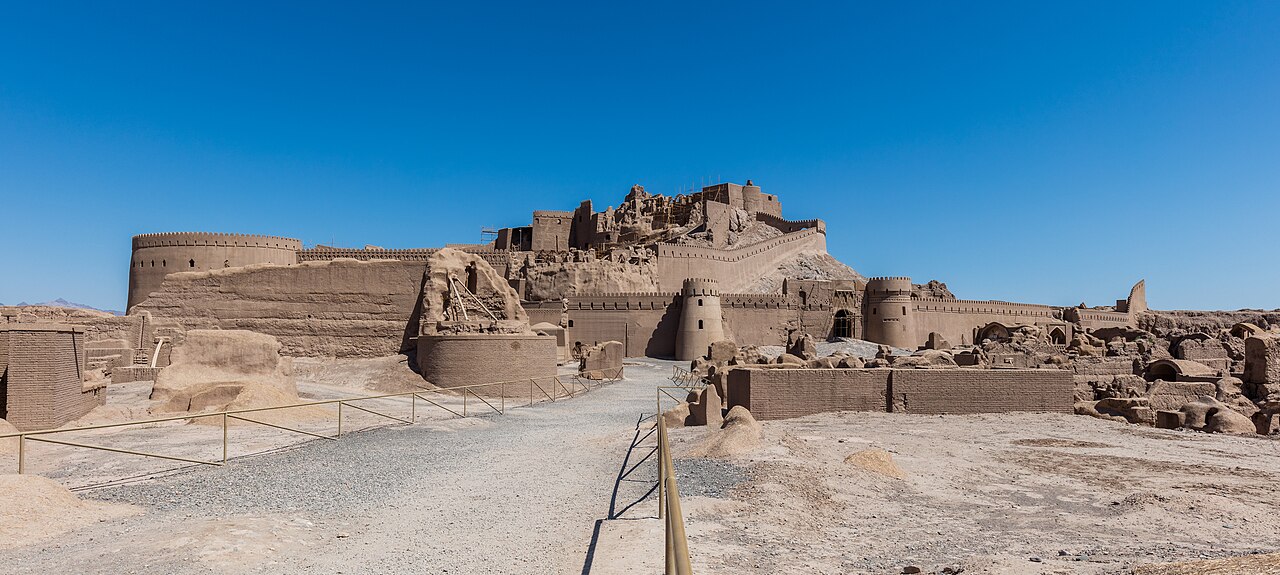
Arg-e Bam is the walled mud-brick town and citadel of Bam in Kerman province, before 2003 probably the largest adobe structure in the world. The earthquake of 26 December 2003 brought most of it down, and it has been under reconstruction ever since. It is the centre of the UNESCO World Heritage Site “Bam and its Cultural Landscape”, listed in 2004.
| Persian name | ارگ بم (Arg-e Bam) |
|---|---|
| Area | About 18 hectares inside the outer wall |
| Walls | About 1.8 km long and 6–7 m high, with 38 towers and a moat |
| Material | Sun-dried mud brick (خشت) and rammed earth |
| UNESCO | Listed 2004; on the List in Danger 2004–2013 |

A whole town in mud brick
The Arg was not just a castle. Inside its outer wall lay a complete town: a main street lined with a covered bazaar, a congregational mosque, a school, a bathhouse, a caravanserai, houses of rich and poor, and stables. At the north end, on a rocky outcrop, stood the government quarter, protected by a second double wall, with barracks, the governor’s residence and a high watchtower above everything. Everything was built of the same earth it stood on, which gave the town its single honey colour.
Nobody knows exactly how old the site is. Claims that it goes back to the Achaemenid period are not supported by firm archaeological dating; a settlement probably existed in Parthian or Sasanian times, and Bam grew rich in the early Islamic centuries on the road between central Iran, Sistan and India. Most buildings standing in 2003 were Safavid or later. The wider story of the oasis, its date palms and its qanats, and the flight of Lotf Ali Khan to Bam in 1794, is told on our page on the city of Bam.
The residents moved out gradually. Building of the new town began around 1900, the Arg was used as a garrison until 1932, and after that it was empty. Restoration began in 1953 and gathered pace from 1973, and by the 1990s the main street and many houses had been rebuilt. The Italian director Valerio Zurlini filmed The Desert of the Tartars (1976) here.
What the earthquake did
The earthquake struck at 5:26 in the morning, with its focus only about 7 km below the town. It killed about 26,000 people in Bam and the surrounding area. In the citadel, the shaking brought down walls and roofs that had stood for centuries: unbaked brick has little strength in tension, and earlier repairs had added weight to old walls. The high watchtower and much of the government quarter collapsed into heaps of earth. Within days President Mohammad Khatami announced that the citadel would be rebuilt. UNESCO inscribed the site in 2004 and put it at once on the List of World Heritage in Danger. More on the disaster in Iran’s earthquake history is on major earthquakes in modern Iran.
Rebuilding: how and how much
Reconstruction has been led by Iran’s cultural heritage organisation, with help from UNESCO and specialists from several countries, among them Japan and Italy. The first years went into clearing rubble by hand, recording what lay underneath, and studying how adobe behaves in earthquakes. Workers have made new mud bricks in the traditional way, and in some places they have added hidden reinforcement. There has been real debate about how much to rebuild: some argue that a reconstructed town is no longer authentic, others that rebuilding with the same materials and methods is the traditional way such towns survived. In 2013 UNESCO judged that enough progress had been made to take Bam off the danger list.
What you can see today
- The main gate and bazaar street. The southern gate and the long bazaar street to the citadel have been largely rebuilt, and give the best idea of the town as it was.
- Houses and the mosque. Some of the larger houses and the mosque along the main street have been restored; others are left as ruins, which shows clearly what the earthquake did.
- The walls and towers. Parts of the outer wall and its round towers have been rebuilt to full height. Seen from outside, especially in the late afternoon, they are very striking.
- The government quarter. Work on the high citadel is the slowest. Depending on progress, parts may be closed, but the view up to it is still the classic image of Bam.
Walk slowly and look at the surfaces: in many places you can see the difference between old and new brick and the layers of repair.
Practical notes
- Bam lies about 190 km south-east of Kerman, about two and a half to three hours by road. Rayen Castle, a smaller mud-brick citadel that survived, is on a route between the two and makes a good comparison.
- Bam is very hot in summer. Visit from October to April, ideally early or late in the day.
- Access to parts of the site changes as restoration goes on. Check current opening hours and tickets locally, and follow your own government’s travel advice for the south-east of Iran.
Persian words from this page
| ارگ | arg | citadel |
| بم | Bam | Bam |
| خشت | khesht | mud brick |
| زلزله | zelzele | earthquake |
| بازار | bâzâr | bazaar |
| برج | borj | tower |
Sources and further reading
- UNESCO World Heritage Centre, Bam and its Cultural Landscape.
- US Geological Survey, summary of the M 6.6 Bam earthquake of 26 December 2003.
- Encyclopaedia Iranica, “Bam”.
- UNESCO World Heritage Centre, state of conservation reports for Bam and its Cultural Landscape (2004–2013), on the reconstruction programme.
Want to learn Persian? Get the free Starter Pack
Get the 14-page printable Starter Pack (all 32 letters, a 7-day reading plan, 100 core words and 20 survival phrases) and a short 5-email course. Free.
More in Top Places to Visit in Iran
- Naqsh-e Jahan Square
- Shah (Imam) Mosque, Isfahan
- Sheikh Lotfollah Mosque
- Ali Qapu Palace
- Jameh Mosque of Isfahan
- Si-o-se Pol and Khaju Bridge
- Vank Cathedral
- Hasht Behesht Palace
- Naqsh-e Rostam
- Eram Garden, Shiraz
- Nasir al-Molk (Pink) Mosque
- Tomb of Hafez (Hafezieh)
- Tomb of Saadi (Saadieh)
- Shah Cheragh Shrine
- Arg of Karim Khan
- Fin Garden, Kashan
- Historic Houses of Kashan
- Jameh Mosque of Yazd
- Yazd Fire Temple and Towers of Silence
- Dowlatabad Garden and Windcatcher
- Amir Chakhmaq Complex
- Golestan Palace
- National Museum of Iran
- Treasury of National Jewels
- Tehran Grand Bazaar
- Milad Tower
- Imam Reza Shrine, Mashhad
- Tomb of Ferdowsi, Tus
- Tomb of Omar Khayyam, Neyshabur
- Tomb of Avicenna, Hamadan
- Ganjnameh Inscriptions, Hamadan
- Behistun (Bisotun): Visiting the Site
- Taq-e Bostan: Visiting the Site
- Tabriz Historic Bazaar
- Takht-e Soleyman
- Armenian Monastic Ensembles of Iran
- Sheikh Safi al-Din Shrine, Ardabil
- Dome of Soltaniyeh
- Alamut Castle
- Falak-ol-Aflak Castle
- Shushtar Historical Hydraulic System
- Chogha Zanbil: Visiting the Ziggurat
- Susa Archaeological Site
- Arg-e Bam
- Ganjali Khan Complex, Kerman
- Shazdeh Garden, Mahan
- Rayen Castle
- Dasht-e Lut (Lut Desert)
- Maranjab Desert and Caravanserai
- Varzaneh Desert
- Mount Damavand
- Hyrcanian Forests
- Lake Urmia
- Badab-e Surt Springs
- Ali Sadr Cave
- The Kaluts of Shahdad
- Qeshm Geopark
- Hormuz Island Colours
- Visiting Persepolis: A Day Trip from Shiraz
- Visiting Pasargadae
- Persian Caravanserais
- The Qanat of Gonabad
- Meymand Village
- Sasanian Sites of Fars: Firuzabad, Bishapur and Sarvestan
- Gonbad-e Qabus: Visiting the Tower
- Zayandeh Rud and Isfahan’s Bridges
- Tochal and Darband: Hiking Above Tehran
- Mount Sabalan
- Skiing in Iran: Dizin and Shemshak
- Golestan National Park